Sunday, June 18, 2023

Redstone & Marble


Nestled between cliff faces of red rock and the Crystal River is the picturesque town of Redstone, Colorado. Originally a coal mining town, Redstone has evolved into an artsy community. The town seems frozen in time.


If quiet life and scenic views are what you are craving, then Redstone is the place for you.


And the Crystal River really is crystal clear.


Throughout the town marble, both decorative and functional, is a common sight. 


This is because the town of Marble is just a few miles away. The Marble Quarry has supplied marble to far more than just Redstone. The quarry has supplied marble for both the Tomb of the Unknown Soldier and the Lincoln Memorial.


Sunday, June 11, 2023

Black Canyon of the Gunnison National Park

The U.S. National Parks are so varied in what they offer that it's hard to rank them in any kind of order. But if Betty and I had to pick a favorite, Black Canyon of the Gunnison National Park would certainly be a contender.

Black Canyon of the Gunnison is one of the newest national parks (established in 1999) and, in our opinion, one of the most breathtaking, perhaps because it is nearly 3 times as deep as it is wide. The result is that, except for mid-day, the bottom is shrouded in black shadow on one side while on the other side sunlight picks out all the colors and veins of rock.

Betty and I had visited the Grand Canyon years earlier. We agreed Black Canyon of the Gunnison is more visually stunning.

The south rim drive runs for just over 7 miles with about 12 pull-off locations. From each pull-off, a short trail leads to a unique view of he canyon.  In wider areas, hoodoos rise from the canyon floor.


 In narrower areas the river has left behind a geological history lesson. Clearly evident are the differing layers and types of rock that make up the inside of the mountain range.


 Everywhere there is evidence the river continues it's unending work of carving deeper into the earth.

Hiking trails are available for all levels of experience. One of the more challenging trails begins at the rim of the canyon and zig-zags its way to the bottom. Of course once at the bottom it's necessary to climb back up. The trail is so challenging that hikers have to register at the park office. I asked if this was so the ranger could assess a hiker's experience and ability.  The answer was a little unnerving. Registration is required so that if a hiker has not returned within an hour of the park closing time, rangers know to go looking.

Needless to say, Betty and I did not register for that trail.

We did run into one very young and fit hiker who had just made his way back to the top. He described the hike as beautiful and intense.


Sunday, June 4, 2023

Royal Gorge Bridge and Park


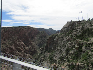
After our visit to the sand dunes, Betty and I ventured to Royal Gorge Bridge and Park. I'm not sure what I was expecting, but I sure wasn't expecting to find myself standing in the middle of a suspension bridge staring straight down nearly a thousand feet to the Arkansas River.


 An amusement park of sorts has built up around this engineering marvel. There's a giant swing, they call it a skycoaster, that flings riders out in midair for a bird's eye view of  the gorge, zip lines, and cable cars.


 We chose the cable car for our first pass across the gorge. 


That cable car left me looking forward to having a solid bridge beneath my feet on the way back across the gorge.

While the bridge was no doubt structurally sound, it did not provide a sense of solidity. The unending parade of people created a continuous bounce. When a motorized jitney came across, I lurched for the handrail and white-knuckled the metal until the worst of the bouncing had passed.

Once in the middle, the views were spectacular. I confess that while on the bridge all of my photographs were taken one-handed, with my other hand firmly gripping a railing or strut.

While the key support system of the bridge is steel, the deck is made of wooden planks. The flags of all 50 states fly along the handrails.


Sunday, May 28, 2023

Great Sand Dunes National Park


Since we had lived near the Delaware beaches for several years we knew about big sand dunes. The sand dunes in Cape Henlopen State Park are some of the biggest on the U.S. east coast.

But what we experienced in Great Sand Dunes National Park took things to a whole new level. Some of the dunes peak out at 750 feet in height. And they change constantly. Due to the high winds and flat plains the sands are forever shifting. 

And I do mean flat plains. 

Once we exited the nearest major roadway we drove for 45 minutes seeing nothing but scrub grass and far distant mountains. I was beginning to wish, once again, that I had filled the fuel tank at the last gas station we had passed. 

Just when I thought that maybe we had slipped into an episode of the Twilight Zone, a Dollar Store appeared. Yep, you can always count on finding a Dollar Store no matter where you are. A Dollar Store meant people, people meant cars, and cars meant a gas station which turned out to be only another 20 miles away.

One of the top things to do at this National Park is to rent a sand sled and sled down the sides of the dunes. But to sled down, you first need to pull the sled up a long, long way. If you have ever gone for a walk in the softer sands along the ocean, you know what kind of effort is involved. 

Betty and I quickly agreed we had neither the leg muscles nor the overall stamina to pull a sled while fighting against sifting sand and the effects of high elevation. Instead we opted to walk along Medano Creek - which only exits for a couple of months each year. The creek is created by snow melt from the relatively nearby mountaintop.


Locals told us that following winters with a heavy snowfall Medano Creek can run about two feet deep for a few weeks. When we were there, the area was still suffering from below average precipitation so the creek was only inches deep.  And cold.

Nevertheless families were enjoying splashing in the water, with younger children flat on their bellies. 

It was obvious that Betty and I were not hearty Coloradans since we were dressed in multiple layers. Splashing in snow melt water? No thank you!


The Great Sand Dunes are certified as an International Black Sky Park, meaning it is a great location to observe the stars with absolutely no light pollution. Unfortunately rain rolled through the night we were there so we didn't get the chance to experience that.


Sunday, May 21, 2023

Colorado National Monument


When Betty said she wanted to take a day trip to Colorado National Monument, I thought we were going to see a structure - like the Washington Monument.

It turns out the Colorado National Monument is 31 square miles containing lots of structures - none of them man made. 

Rather than hoofing it on hiking trails, we decided to take our truck on Rim Rock Drive. The 23 miles of roadway rises roughly 2,500 feet as it skirts the edges of red rock cliffs. A snake would be envious of all the curves in this drive. Every turn offered an even more breathtaking vista.

 At least that's what Betty said,

I dared not take my eyes of the roadway which was just wide enough for two cars. Since we were in a pickup truck with dual wheels on the rear axle, our vehicle width was a little wider than average. When a car did come the other way I found myself wondering if both vehicles would pass without damage. For the most part guard rails were non-existent. A miscalculation by the driver on the outer side of a curve would result in a substantial plummet.

We made it through without incident, though Betty did confess she sometimes leaned to the center of the truck to keep it from toppling into the canyon.

 There were several pull-offs where Betty and I were able to equally enjoy landscapes that went on forever.


After one such stop, Betty asked if I wanted her to drive the remaining part of the roadway. I said I was fine to keep going. Later Betty told me she would be forever grateful of my decision.

Independence Monument, shown in the top picture, is all that remains of what used to be a solid canyon wall. Apparently getting to the top of the Monument is considered a fun, recreational climb by many outdoorsy types.On July 4th of every year there is a climb to place an American flag at the top.

Throughout Colorado National Monument, we saw where erosion is slowly changing other walls of rock into individual monoliths.


Sunday, May 14, 2023

Silt Colorado


 The fuel stop that we had reached running on fumes turned out to be immediately adjacent to the campground where we would be work camping for five months. The campground was located in Silt, Colorado which was a small town where none of the restaurants knew how to cook a good pizza or build a good sub. But since we were traveling with our own kitchen that proved to be a relatively minor inconvenience.

The KOA campground was relatively new with some spacious RV sites, and beautiful views of the surrounding mountain ranges. It was a different experience to step outside in the morning sunshine and see snow-capped mountains. 


Silt is located in the region known as Colorado's high desert. The high desert sits between mountain ranges that split in a V to the north and south. Frequently approaching storms would blacken the skies to the west. Thunder would echo and heavy rain would form an encroaching gray wall. And then, like Noah parting the Red Sea, the wall would split.  There would be rain to the north of us and rain to the south, while we were left in the middle with not a drop of moisture


. When we arrived in April, nighttime temperatures were in the mid to low 30's with daytime temps climbing to the upper 70's / low 80's. By the time time July  rolled around is was just plain hot with nights in the upper 70's and daytime temps breaking 100 on a fairly regular basis. 

What we had heard about dry heat proved to be true. One hundred degree temperatures are much more tolerable when the humidity is low. But on those occasions when a mid-day thunderstorm did roll through, everyone wilted when the sun came back out.

The way the work camping thing worked for us was we worked 24 hours over 4 days. The schedule was structured so that we had 3-1/2 consecutive days off. That gave us lots of opportunities to explore Colorado including State Parks as well as National Parks and Monuments.  

Because Silt is just shy of one mile above sea level we knew we needed to be fully adjusted to the altitude before setting off on any strenuous hikes or walks. We started off walking the nature trails near the campground. Parts of the trail followed the Colorado River and watery offshoots where lots of beaver could be spotted around dusk.

There was evidence everywhere of just how industrious the beavers were. However they didn't necessarily take into account that if they gnawed a twelve foot tree it would get hung up in the neighboring trees rather than falling to the ground. All that hard work with no wood to add to the lodge must have been discouraging.


Sunday, May 7, 2023

Learning Curves


 We pulled out of Bear Creek Lake Campground onto roads that were damp from soupy fog. We had 172 miles to cover. There was three-quarters of a tank of fuel in the truck which allow us to cover 225 miles. If we used fuel at a slightly faster than normal rate, well, we would be on an interstate so there had to be places to get diesel. 

After all, tractor-trailers run the interstate system 24/7.

There were several things we failed to consider, the first of which, by itself, should have kept us from leaving the campground. 

When driving on wet roads and heading into elevations where the temperature is thirty-five degrees colder, the wet roads will quickly turn to icy roads. 

Driving on icy roads pulling a 40 foot RV was never on my bucket list - and is something I will never repeat. 

The second thing we failed to consider was that when driving in mountainous regions where the temperature has just dropped 45 degrees in three hours, nearly every valley will be filled with fog that reduces visibility to something like 20 feet. 

Visibility of 20 feet when going down a 12 percent grade with 14,000 pounds of RV trying to push your vehicle faster results in an experience roughly equivalent to jumping off a diving board with your eyes closed.

Pulling off the road was not an option because of the sheer cliff faces that met the highway at the solid white stripe on the right.

The third thing we should have considered was.... the Rocky Mountains are exponentially higher that the Adirondacks. The inclines and declines are extreme and long. Fuel mileage decreases not by just a little but by 25 percent.

And so it was that about 150 miles into our drive I looked at another long incline ahead of us - and the position of the needle on the fuel gauge. And I realized we would run out of diesel before we reached our destination.

At that point I was thinking I should have taken an extra dose of blood pressure medicine at breakfast.

But the universe had not abandoned us entirely. When we crested the incline, we found ourselves in sunshine - and there was a pull-off for a scenic overlook. 

Never had a pull-off ever looked so beautiful, scenery or no. 

And I was about to enjoy a little known occurrence. An apology from my significant other - who had made fun of me for carrying a 5 gallon can of diesel in the bed of the pickup just in case.

Those 5 gallons got us to the next fuel stop - with one gallon to spare.

But first... we had to navigate the Glenwood Canyon section of I70. We later learned that construction of these 12 miles of roadway was the most expensive part of the entire interstate system. The road snakes between cliff faces, through tunnels, and in some places hangs seemingly suspended above the Colorado River. A picture of a small section of this stretch of road is shown at the top of this post.

Whew... I'm exhausted reliving those few hours of my life.  

Lessons learned from this experience.

Plan every part of every trip in advance.

Never leave a campground with less than a full tank of fuel.

Always know where fuel stops are along the entire route.

The weather doesn't care about you.